

Historic Railroad Map of Ohio & Indiana - 1850
Description
Terre Haute and Richmond Railroad and connecting lines.
The Terre Haute & Richmond Railroad was chartered in 1847. The plan for the railroad was to cross Indiana by way of Indianapolis.
In the 1850's, the route’s portion from the Ohio state line to Indianapolis was reorganized as the Indiana Central Railway, while the line’s section from Indianapolis west to the Illinois state border was called the Terre Haute & Indianapolis Railroad.
The world’s first Union Station was built in Indianapolis in 1853. The station included a large brick train shed located at the point where several rail lines converged. The station was remodeled in the 1880's into the large brick structure that can be seen today.
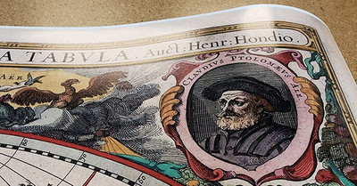
This outline map of the north-central and northeastern United States was published in the 1850's by Thomas A. Morris. It displays state boundaries, major place names, iron and coal deposits, waterways, and the railroad network with distances noted. Additional railroad connections have been earlier indicated using pencil.
The Terre Haute & Richmond Railroad was chartered in 1847. The plan for the railroad was to cross Indiana by way of Indianapolis.
In the 1850's, the route’s portion from the Ohio state line to Indianapolis was reorganized as the Indiana Central Railway, while the line’s section from Indianapolis west to the Illinois state border was called the Terre Haute & Indianapolis Railroad.
The world’s first Union Station was built in Indianapolis in 1853. The station included a large brick train shed located at the point where several rail lines converged. The station was remodeled in the 1880's into the large brick structure that can be seen today.
This outline map of the north-central and northeastern United States was published in the 1850's by Thomas A. Morris. It displays state boundaries, major place names, iron and coal deposits, waterways, and the railroad network with distances noted. Additional railroad connections have been earlier indicated using pencil.
Materials
Archival Paper

Premium fine art paper that provides accurate color reproduction with high-contrast, high-resolution print output and maximum image permanence. A high-quality print ready for framing.
More
- Museum quality paper for high-quality fine art.
- Ultra smooth, neutral white matte finish.
- Heavy-weight 230 gsm, 9.5 mil thickness.
- Printed with pigment inks for longer print life and enhanced fade resistance.
- Pigment based Canon LUCIA inks provide smooth tones and rich colors in fine, precise detail.
Luster Photo Paper
A premium semi-gloss photo paper with a subtle texture that produces a vivid, richly detailed print. This material results in an exquisitely detailed giclee print of substantially higher quality than a standard poster.
More
- Printed on 10 mil premium luster photo paper resulting in a brilliant, colorful image with a vivid life-like quality.
- Pigment based Canon LUCIA inks provide smooth tones and rich colors in fine, precise detail.
- Inks have a lightfastness rating of over 100 years, guaranteeing minimal noticeable fading over a very long period of time.
- Printed using very high resolution source files.
- Giclee printing is superior to traditional lithography in a number of ways: colors are brighter, lasts longer, and is a higher resolution.
Canvas on Wood Rails
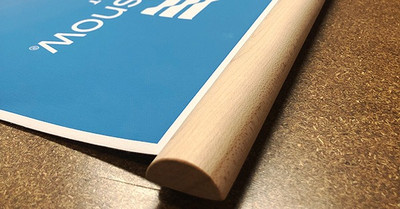
A canvas giclee print is mounted to wooden hanging rails placed along the top and bottom of the map. Ready to hang on the wall using the attached hanging cord. Wood rails feature a natural finish.
More
- Premium 19 mil canvas material.
- Wood rails are 1 1/8" wide, round front.
- USA sourced solid maple wood.
- High quality giclee fine art print with a lightfastness rating of over 100 years.
- Pigment based Canon LUCIA inks provide smooth tones and rich colors in fine, precise detail.
Canvas Gallery Wrap
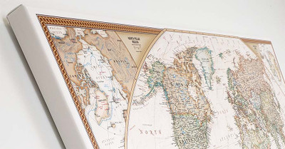
A high quality canvas giclee print is hand stretched over a sturdy wood frame. Printed on demand and handcrafted in Seattle, WA. The canvas gallery wrap serves as a stunning piece of art ready to hang on your wall.
More
- Premium 19 mil canvas material.
- Pigment based Canon LUCIA inks provide smooth tones and rich colors in fine, precise detail.
- High quality giclee fine art print with a lightfastness rating of over 100 years.
- Durable canvas mounted to a 1" deep wood frame.
- Ready to hang with included easy-to-use hanging kit.
Framed Map Print - Black Finish
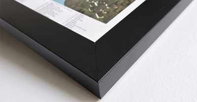
Our gallery quality frames are made of solid wood and feature optical-grade acrylic. Each framed map is printed on premium archival matte fine art paper.
More
- Printed on thick, luxurious acid-free fine art paper & dry-mounted to foam board.
- Pigment inks ensure a vivid print with amazing colors and excellent fade resistance.
- Solid wood frame with a black finish has a 1.25" face & 7/8" depth.
- Kraft paper protective backing & hanging wire installed.
Framed Map Print - Natural Oak Finish
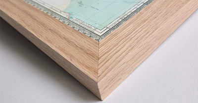
Our gallery quality frames are made of solid wood and feature optical-grade acrylic. Each framed map is printed on premium archival matte fine art paper.
More
- Printed on thick, luxurious acid-free fine art paper & dry-mounted to foam board.
- Pigment inks ensure a vivid print with amazing colors and excellent fade resistance.
- Solid wood frame with a natural oak finish has a 1.25" face & 7/8" depth.
- Kraft paper protective backing & hanging wire installed.


