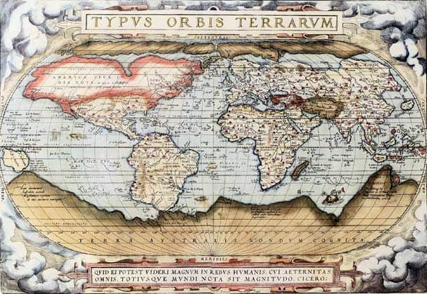
During the latter portion of the 16th century map making became predominant in the Low Countries, first in Antwerp, then Amsterdam, which became the leading producer of maps until early in the 18th century. Most notable of this region is Abraham Ortelius, perhaps one of Europe's foremost cartographers. Ortelius is well known today for compiling the first world atlas in 1570 which he titled Theatrum Orbis Terrarum. This compilation made up the first bound collection of uniform size that presented all known parts of the world. This book of maps became the most successful cartographic production to date and was issued over a period of 40 years in just as many editions translated in seven different languages. The first edition consisted of fifty-three sheet maps. By the time of Ortelius's death in 1598 his atlas had been expanded to contain 119 map sheets. Other than being a massive production this composition was unique in the fact that it featured text describing each area and gave credit to each author of the original maps which he had copied.

Ortelius World Map, 1570
Ortelius worked closely and maintained a friendship with another well known cartographer of his time, Gerard Mercator. In 1585 Mercator published his "Atlas'' Part One, consisting of 51 maps of Holland, Belgium, and Germany. This publication was the first to be called "Atlas". Part Two of the "Atlas", appearing in 1589, contained maps of Italy, Greece, and Central Europe and Part 3 containing maps of The World, Continents, British Isles, and Northern Europe appeared in 1595. Mercator died in 1594 and his son Rumold, who died five years later, took over publishing of his "Atlas", which were issued in one ore sometimes two volumes. It was his son who added the World maps and Europe to the last part of the "Atlas".
In 1606 Dutch map maker Jodocus Hondius purchased the map copperplates from the Mercator family and reissued the Atlas adding new maps to the compilation, particularly of Africa, Asia, and America. After Jodocus Hondius died in 1612 his widow and sons, Jodocus II and Henricus took over the publication, continuing until 1623. In 1629 Henricus sold a number of the printing plates to Willem Janszoon Blaeu, but continued production of the "Atlas" with Jan Jansson. In 1638 Jansson added new plates and reprinted the publication as the Atlas Novus. Jansson's efforts, in competition with Blaeu, eventually produced an exceptional nine-volume Dutch edition in German and Latin.
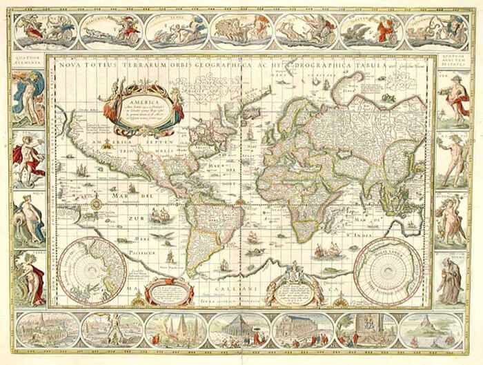
Williem Janszoon Blaeu and his son Joan produced some of the finest work in Dutch map making. In Amsterdam Blaeu setup a business initially as a globe and instrument maker and very soon after became a publisher of charts and maps. From 1596 his major output was terrestrial and celestial globes sold in pairs of various sizes and finely made navigation and astronomical instruments. The first map Blaeu published was in 1604 of the Seventeen Provinces and was followed by single sheet maps of various European countries. Most significant of these maps was his World wall map of 1605 printed on 20 sheets, spanning eight feet across. This map was the best of its kind during this period and remained the model World map used by many other map makers until 1648 when his sons superseded it. His next major publication was an atlas of European coast charts, first published in 1608. In 1630 Willem Blaeu published the first land atlas after thirty years of producing separate map publications. During this time he also published books that covered the sciences, classics, and literature.
In 1629 Blaeu had purchased nearly 40 of the Jodocus Hondius II map plates, these ended up forming the bulk of Blaeu's Atlantis Appendix, which was also made up of many of the single sheet maps he produced over the previous 15 years. At this time Willem Blaeu's son Joan was assisting him with enlarging the Appendix in 1631 and then publishing its replacement titled either Novus Atlas or Theatrum Orbis Terrarum from 1634 to 1635. After the death of Willem in 1638 his son Joan continued the business eventually publishing the family's most famous work entitled Atlas Major. The Atlas Major was published between 1662 and 1672 varying from nine to twelve volumes containing around 600 maps. The Atlas Major is considered the crowning achievement of the Blaeu family and to be the epitome of style and quality during a period known as the "golden age" of Dutch map making.
The Atlas Major was far more popular than Jan Jansson's 1662 printing of his eleven volume Novus Atlantis Absolutissimus. Even though many of the maps contained in Joan Blaeu's atlas had an origin of forty years before the publication, the quality of engraving, typography, paper used, of binding offered, and in house coloring far outshined that of Jansson's. In fact the distinct quality of Blaeu's production made it worthy of presentation to foreign dignitaries as a symbol of the Dutch Empire and its expert craftsmen. During the period of its publishing Atlas Major was one of the most expensive books ever produced.
In 1672 production of the Atlas Major came to a halt after a fire at the Blaeu's warehouse destroyed much of the their stock of copper plates and printed material. One year later Joan Blaeu died and remaining stocks were auctioned off over the next few years. It was soon after these events that Dutch map making began to decline in favor of the French.

Willem Blaeu World Map, circa 1640
