Panorama Maps Of The 19th Century
Some of our favorite Panorama Maps are Bird’s-Eye-View style, popularized in the mid-1800s and early 1900s. These views are a hybrid of cartography and art. The artists captured the character of neighborhoods using original maps, blueprints, and plans in conjunction with skillful sketching of a city’s features and buildings.

The lithography process that was used to reproduce these views was relatively new, having only been introduced in the early 1800s. The idea of printing on paper from an image placed on stone was quickly embraced. Rapid advances with steam-powered mechanics made the process ever more efficient and economical. The early lithography equipment and supplies were produced in Europe, with American printers importing the presses and supplies from Germany, England, and France. Only three American patents related to lithography were issued prior to 1860. As the process became more mechanized, American printers began demanding more of the powerful new presses. The R. Hoe & Co. of New York began to manufacture steam-powered presses as early as 1870 in New York. Further advances rapidly followed, such as the use of zinc plates that were easier to use than stone, and the development of photographic processes. The Centennial Exposition of 1876 exhibited the earliest examples of prints made using the photozincographic process at the Photographic Hall in Philadelphia.

With the benefit of hindsight, we see the years immediately following the Civil War as those of a nation interrupted. Not only were citizens reeling from the grief and loss of war, but the sense of hope and pride that must have filled the hearts of men and women in the young republic seemed to have lost its pure form. In what seemed like a swelling wave, patriotic pride gripped much of the nation, with an emphasis on getting on with business and expanding the country westward. Any display of patriotism for one’s country, state or town became the craze. Festooning every office, boardroom, and parlor across America were etchings, drawings, paintings and photographs; things emblematic of civic pride being among the favorites. Lithographers and print shops were kept humming with printing projects that the public eagerly consumed. Most popular among the new prints were panorama maps; views of towns and cities drawn and published by a handful of artists and lithographers.

AMERICAN PROGRESS – 1872, PAINTING BY JOHN GAST. TYPICAL OF THE CRAZE FOR PATRIOTIC ART,
PRINTS WERE WIDELY CIRCULATED IN THE 1870S.

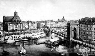
THIS VIEW OF PARIS IN 1840 SHOWS THE SLIGHTLY ELEVATED PERSPECTIVE THAT WAS THE EUROPEAN
STANDARD FOR SKETCH ARTISTS PRIOR TO THE CIVIL WAR.
Views of towns were usually painted or sketched from a slightly elevated perspective following the standards of European artists prior to the Civil War. While the result was a pleasing picture of a place, the details of elements in the distance were lost behind the foreground. Following the Civil War, possibly due to the influence of photographs that were now available for public consideration, the perspective shifted to a much higher elevation being imagined, with a town’s layout of buildings and streets and distant backgrounds visible within the perspective.

NEW YORK CITY, 1883 – PROPOSED SITE OF THE WORLD’S FAIR
The growing enthusiasm for print media to be displayed in homes and businesses across America was well-timed for the leaps forward taken by the printing industry. As the public’s taste for material that expressed their affection for all things American increased following the Civil War, their interests turned toward anything that affirmed the local and regional pride many felt for their towns and cities. The artists and publishers were poised to supply the demand. A small and industrious group of artists pursued the new form of “Bird’s-Eye-Views” or “Panoramic Maps” with fervor. Most prints were sold on a subscription basis. Advertising and pre-sales of copies assured the publisher’s overhead costs would be met before committing to the expensive lithography process. Once the printing was complete, the prints were published and distributed to the subscribers. The promotion of pre-sales was part of the job of the itinerant artist who arrived to work on sketches of the proposed town. More successful artists were able to use agents for this task, some of whom were also sketch artists. Carefully-timed press releases announced the arrival of the artist or agent and a pre-sale psychology was employed, announcing the “possibility” of a finely sketched view of the town if enough subscriptions were sold. Sales calls on local merchants to offer featured space in the form of vignette sketches that adorned the margins or for directory inclusion were made during the agent’s stay. It is not difficult to imagine that a bit of rivalry between local businesses could be encouraged to increase sales. It was also advantageous for the agent to connect with the local Chamber of Commerce or other civic groups who saw the maps as an excellent way to promote the benefits of their community, thereby recruiting some of the community’s most powerful businessmen to encourage subscriptions.

OAKLAND, CALIFORNIA BIRD’S EYE VIEW MAP, 1900
Civic booster organizations saw panorama maps as an excellent way to attract new immigrants from Europe and inspire those who were considering immigration. Sometimes the maps included a “booster” statement expounding on the quality of the air and the purity of the water. Even without advanced English language skills, a European could view one of these perspective views of a town or city and get a feel for the character of the community through the image alone. The minimal text listing businesses, churches, schools, and civic centers gave the potential immigrant a broader understanding of the community than one might receive from a letter home or word-of-mouth.
The commercial approach to the business of publishing these prints caused the art and design communities to largely ignore their artistic merit. Now valued as historical documents, the maps can be appreciated both for their design elements and for the documentation that the commercial content provides to scholars.